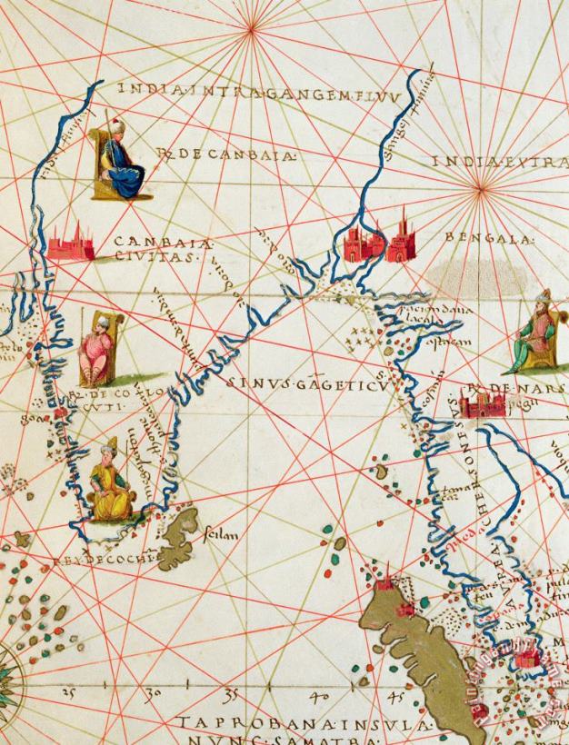
About India and Malaysia Canvas Prints
Stretched Canvas Prints
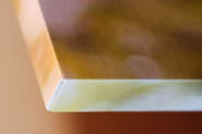
Corner Detail: Stretched canvas print with 0.8" stretcher bars.
Enjoy the beauty of Battista Agnese India and Malaysia without breaking your banks with a stretched canvas print. Your image gets printed on canvas and then stretched on a wooden frame of stretcher bars (gallery wrap). Ideal for office or home display. All stretched canvases ship within 2 - 3 business days and arrive "ready to hang" with pre-attached hooks and nails.
Battista Agnese India and Malaysia stretched canvas prints look beautiful with or without frames.
paintingandframe.com is one of the largest giclee printing companies in the world producing museum-quality prints. All of our Battista Agnese India and Malaysia prints are waterproof, produced by professional-grade Epson printers. We use acid-free cotton canvas with archival inks to guarantee that your prints last a lifetime without fading or loss of color.
If Battista Agnese India and Malaysia is printed by machine on textured canvas, it takes about 5 working days to your address; if you choose it as hand painted reproduction, it takes about 18 working days to your address. Please keep in mind that all of our products are waterproof on textured canvas! We ship India and Malaysia all over the world.
Our return policy is very simple:
If you're not happy with Battista Agnese India and Malaysia that you made on paintingandframe.com, for any reason, you can return it to us within 50 days of the order date. As soon as it arrives, we'll issue a full refund for the entire purchase price. Please note - paintingandframe.com does not reimburse the outgoing or return shipping charges unless the return is due to a defect in quality.
We sell thousands of pieces of artwork each month - all with a 100% money-back guaranteed.
If you want to purchase mueseum artwork at discount price, why not give us a try? You will save a lot more!
![Guillaume Raynal Northern India painting]()
Northern India
![Guillaume Raynal Southern India and Ceylon painting]()
Southern India and Ceylon
![Nicolaes Visscher Claes Jansz General map extending from India and Ceylon to northwestern Australia by way of southern Japan painting]()
General map extending from India and Ceylon to northwestern Australia by way of southern Japan
![Battista Agnese The Kingdoms of England and Scotland painting]()
The Kingdoms of England and Scotland
![English School Antique Map of New York painting]()
Antique Map of New York
![English School Military plan of the North Part of Rhode Island painting]()
Military plan of the North Part of Rhode Island
![English School Map of the West Indies Florida and South America painting]()
Map of the West Indies Florida and South America
![Italian School Antique Map of Naples painting]()
Antique Map of Naples
![American School Map depicting North America as Divided by the European Powers painting]()
Map depicting North America as Divided by the European Powers
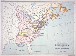
![American School Map of the Colonies of North America at the time of the Declaration of Independence painting]()
Map of the Colonies of North America at the time of the Declaration of Independence
![Abraham Ortelius Map of North and South America painting]()
Map of North and South America
![French School Antique Map of France painting]()
Antique Map of France
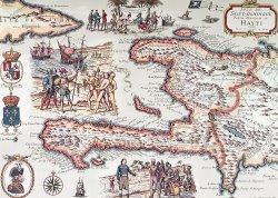
![French School Map of the Island of Haiti painting]()
Map of the Island of Haiti
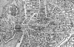
![French School Detail from a map of Paris in the reign of Henri II showing the quartier des Ecoles painting]()
Detail from a map of Paris in the reign of Henri II showing the quartier des Ecoles
![Cristoforo Buondelmonti A map of Constantinople in 1422 painting]()
A map of Constantinople in 1422
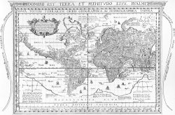
![Dutch School Nova Totius Terrarum Orbis Geographica Ac Hydrographica Tabula painting]()
Nova Totius Terrarum Orbis Geographica Ac Hydrographica Tabula